
Photo: Geographic information system (GIS) data can help education policymakers make more informed decisions.
Around the world, individuals are using maps to power everyday decisions: how do I navigate from my home to the nearest hospital? How many supermarkets are in my community? What public transportation is available for me to take to work?
But the use of geospatial data extends far beyond the day-to-day decisions of individuals. Geospatial data can inform systems planning, supporting global, national, and sub-national stakeholders to make more equitable decisions about resource and service allocation. The Open Cities Africa project collects geospatial data to support urban planning and better manage natural hazards such as coastal erosion. Humanitarian organizations like Médecins Sans Frontières and the British Red Cross rely on mapping data to reach those in need during crises. And organizations such as the World Resources Institute have created partnerships to leverage geographic information system (GIS) data for monitoring natural resource consumption through platforms like Global Forest Watch.
Yet, in the education sector, the use of geospatial data has remained relatively limited despite an increased emphasis on evidence-based decision-making. However, promising applications of GIS are beginning to emerge. In Sierra Leone, the Education Commission’s Education Workforce Initiative (EWI) has used spatial analysis to identify ways to improve the supply and demand of teachers across the country. In India, Educate Girls uses GIS to support their efforts to increase the number of girls in school in rural areas. In Nigeria, GRID3 has utilized geospatial data to inform school planning at a national level. And globally, UNICEF is working to map every school worldwide using machine learning.
And now, the Education Commission has launched the GIS for Education Working Group with education and non-education sector actors to build on this momentum. The working group, co-chaired in partnership with EdTech Hub, will drive conversations and actions to harness the power of GIS to support education decision-making and advance SDG 4. By strengthening collaboration and coordination across stakeholders, the working group aims to:
- Conduct a light-touch communications campaign on the need for, utility of, and cost-effectiveness of geospatial data and analysis for decision-making within the education sector
- Foster cohesion across education and non-education sector actors working with GIS to create and use existing data sets, share findings, and partner on specific projects
- Develop practical tools and documentation to support policymakers to undertake GIS- informed analysis for decision-making
- Explore new ways geospatial data can be used to visualize education issues at a global or regional level
How geospatial data can pave the way for advancing SDG 4
While some advances in global, national, and subnational data collection have been made in education, challenges still remain with using this data for decision-making. GIS enables visual and spatial representations of available data sources, bringing otherwise static numbers to life in a way that can help policymakers and leaders make more informed decisions. Different types of GIS data from various sources can also be overlayed to help discern and illustrate the independencies, or dependencies, between decisions.
For example, as part of EWI’s work in Sierra Leone, Fab Inc. mapped education workforce challenges using GIS data. Below, the map on the left shows the shortages of specialist English, science, and math teachers across the country. Combined with the map on the right which shows where specialists are under-utilized, the data can inform solutions for improved workforce allocation.
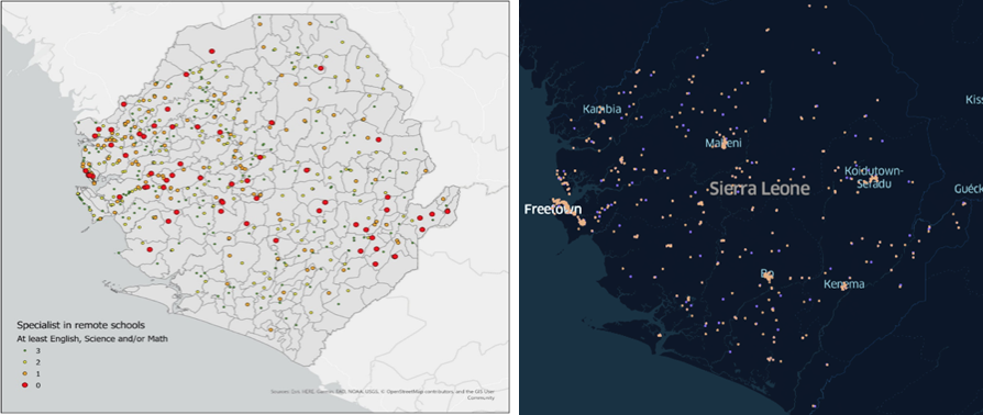

Example of GIS use in Sierra Leone: the map on the left shows shortages of specialist teachers and the map on the right shows schools with under-utilized specialists (orange) and in-need schools within 5km (blue)
The working group will promote the collection and use of this type of geospatial data to support decision-makers to better target interventions to deliver inclusive and quality education for all.
If you are interested in joining the working group, please submit your interest here and we will be in touch about upcoming meetings.